Submission to Macquarie Point Northern Access Road Consultation
A new road is being built to service the Port of Hobart and the stadium precinct. We've been fighting to make sure it doesn't forget the thousands of people who will walk and ride through this corridor every day.

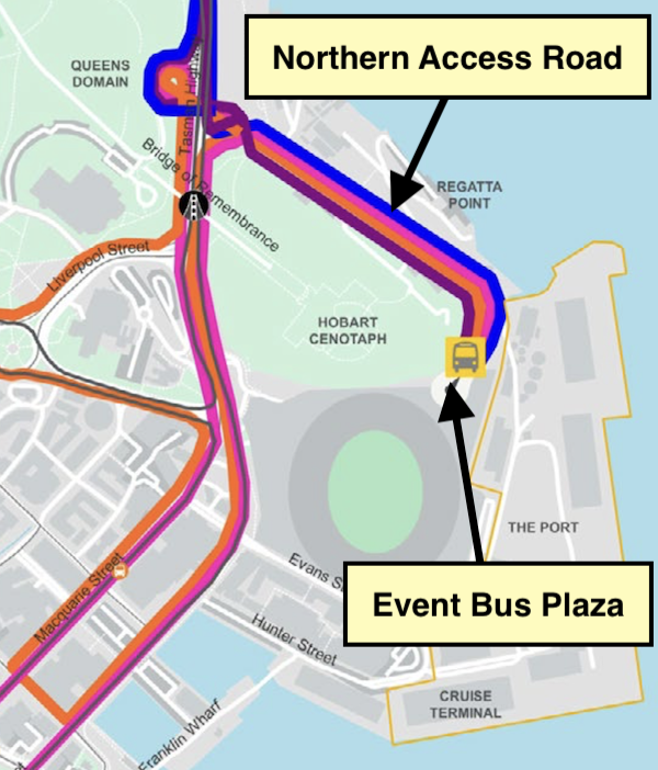
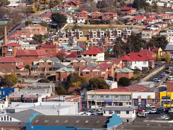
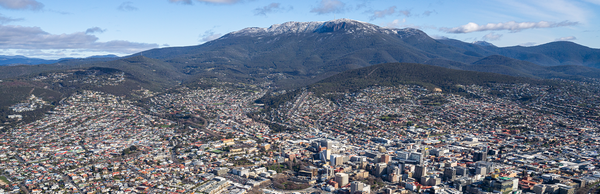
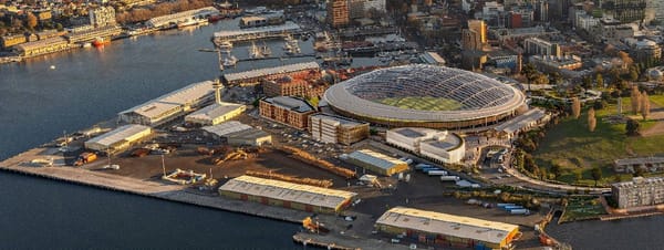
The Macquarie Point Northern Access Road will link the Tasman Highway to the Port of Hobart, provide a dedicated bus plaza for stadium events, and connect the broader Macquarie Point precinct including the future Antarctic facilities. It's a major piece of infrastructure — and it cuts right through the busiest walking and cycling route in the city.
The Intercity Cycleway carries hundreds of commuters and recreational users through this area every day. With the stadium expecting 25% of patrons to arrive on foot or by bike, those numbers are only going up. If the road design gets active transport wrong, the consequences will be felt for decades.
So we've been making sure our voice is heard — at every stage.
We submitted to the Parliamentary Standing Committee on Public Works inquiry in early February, one of 21 submissions received. We then attended the public hearing at Parliament House on 12 February to give evidence in person, tabling additional material on off-road path crossing treatments directly to the committee.
We also responded to the separate public consultation run by the Department of State Growth's project team. After walking the site with them, we followed up with a detailed submission pushing for a comprehensive transport plan for the whole precinct — not just a road design with a cycleway bolted on as an afterthought. We called for separated paths, safer intersections, 30 km/h traffic speeds, and proper connections between the cycleway, the Domain, and the future ferry terminal.
The Tasmanian Walk, Wheel, Ride Policy says all transport projects must provide for all modes. We're holding them to it.
Our full submissions are below.
Submission to the Public Consultation for the
Macquarie Point Northern Access Road
19th February 2026
Prepared by Dominic Lang
Reviewed, endorsed and submitted by Hayden Norfolk, Vice President
Contact: [email protected] | streetspeoplelovehobart.au
Thank you for the opportunity to walk the site with the project team and to provide feedback on this project.
Streets People Love Hobart is a community-led initiative organised by a passionate group of local advocates, and supported by many local businesses. Our mission is to engage people and advocate for streets that prioritise people, safety, and sustainability. We believe Hobart deserves vibrant, welcoming spaces where everyone can connect, move, and thrive.
Streets People Love Hobart:
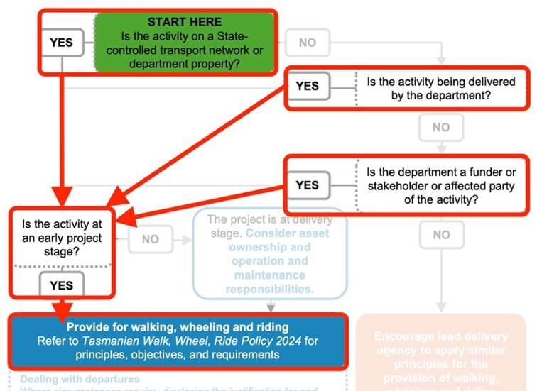
1. Emphasises the importance of the area north of Macquarie Point for active transport and the obligation for the northern access road project to provide for all modes of transport under the Tasmanian Walk, Wheel, Ride Policy (Figure 1).
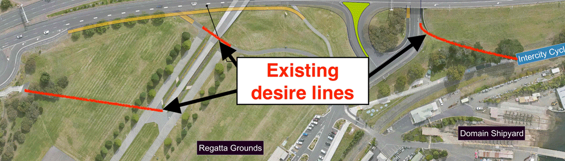
2. Strongly recommends careful consideration of movement patterns of people walking and riding throughout the wider precinct to inform a comprehensive transport plan for the area. Multiple desire lines are clear evidence that there is room to improve existing routes (Figure 2).
Examples of potential improved path routes include:
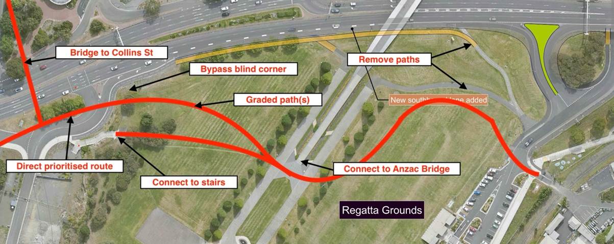
2.1. Cycleway—City (Figure 3): Route through the parklands rather than along the highway. Pass the end of the Anzac Bridge for better connection to the Domain and to the city via the Rose Garden Bridge. Connect to the existing disconnected stairs. Bypass the existing blind corner on the shared path. Redesign the turnout near the Royal Engineers to allow for more direct and prioritised movement of people walking and riding. Connect to the Collins Street active transport bridge specified in the Stadium Transport Study, thereby grade separating people walking and riding from the heavy traffic of the Brooker-Tasman-Davey-Macquarie confluence.
This route would also simplify logistics during the construction of another southbound lane on the Tasman Highway.
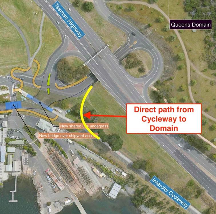
2.2. Cycleway—Domain (Figure 4): Formalise the existing desire line from the Cycleway under the Tasman Highway to the Domain.
2.3. Stadium—Ferry: An all ages and abilities route directly from the stadium to the site of the planned ferry terminal. There is a rare opportunity to make a feature of this section of foreshore which remains publicly accessible.
3. Supports changes to the design to replace the underpass with a less confined route under the road to improve people’s perception of personal safety.
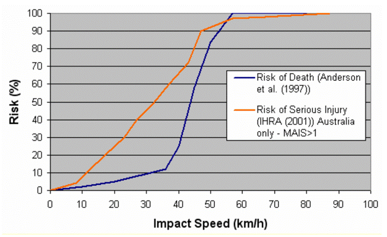
4. Supports targeting traffic speeds of 30 km/h along the road to minimise risk of collisions between people and vehicles, and to reduce risk of death or serious injury in the event of a collision (Figure 5). The current road design — wide, level, straight, wide corners — is not in itself conducive to this outcome.
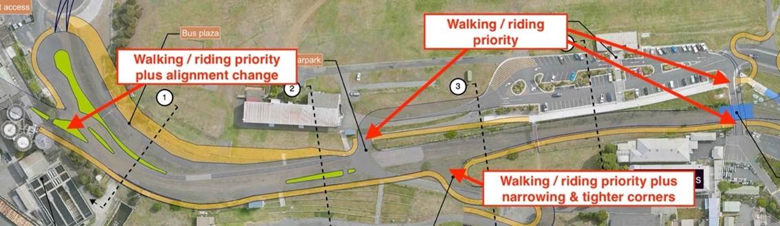
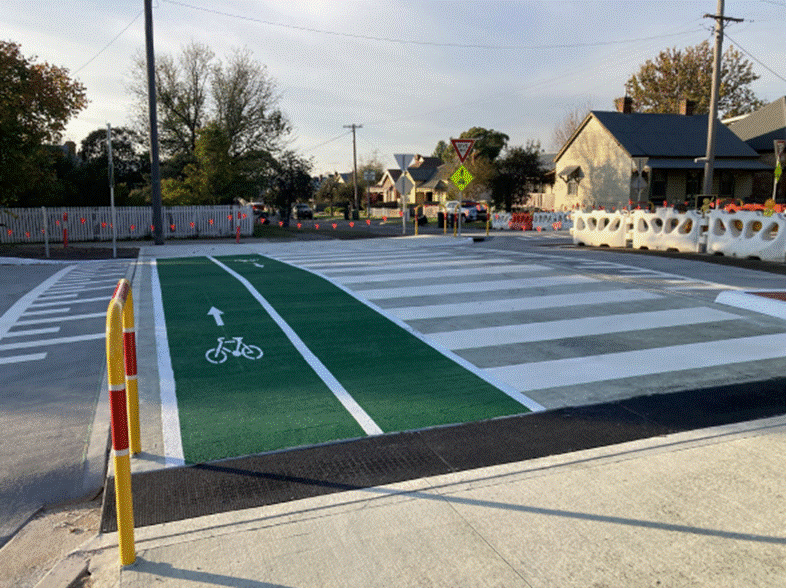
5. Supports priority crossings for pedestrian and bicycle paths at intersections (Figure 6, Figure 7).
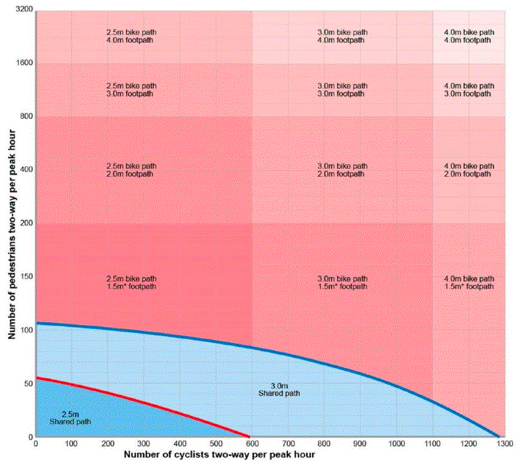
6. Encourages modification of the design to incorporate separated paths for walking and riding. Existing usage patterns already exceed shared path limits (Figure 8). Stadium events will generate additional people walking and riding, making separation even more essential.
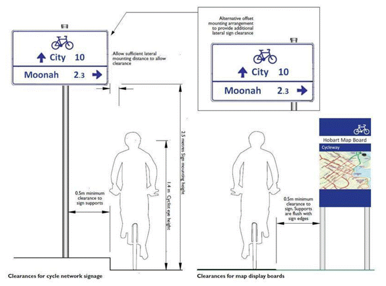
7. Suggests detailed designs incorporate well-considered signage to provide effective wayfinding for people walking and riding.
8. Suggests a considered plan for landscaping. Trees should be used to calm traffic, as well as provide sun and wind protection for people walking and riding.
9. Suggests that any protective barriers preserve visual connectivity with the surrounding natural landscape, including views to and across the River Derwent, recognising the importance of these views to community amenity and experience.
10. Suggests the project planning includes provision of amenities for people walking and riding, such as:
10.1. Lighting for the walking and cycling paths.
10.2. Bike parking.
10.3. Places to stop, rest and enjoy the view. Seating. Drinking water. Bins.
10.4. Security cameras. Emergency call points.
10.5. Public artwork.
Finally
Thank you again for the opportunity to comment on this important project. We look forward to seeing the design evolve from a road design to a comprehensive transport design, facilitating efficient and safe movement of people by all methods of transportation, and protecting the most vulnerable road-users in our community, such as wheelchair users, cyclists, and pedestrians, of all ages and abilities.
Yours sincerely,
Hayden Norfolk,
Vice President, on behalf of Streets People Love Hobart.